KSi
Knowledge Sciences, Inc.
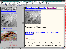
Hypermedia Terrain Database (HTD)

(click on image for a larger view)
-
Utilizes the ability of hypermedia technology to organize terrain image interpretation collateral material in a highly interactive digital softcopy form.
-
Used by Army Terrain Analysts to match patterns seen in LANDSAT and airphoto imagery, to patterns in the the database for subsequent access of information relating to military operations (e.g. troop and vehicle mobility factors).
-
Distributed via CD-ROM to US Army Terrain Teams stationed all over the world.
-
Currently available over the classified Intelink(TS) network on the Topographic Engineering Center's (TEC) home page. A public version is available on the TEC Internet home page.